
TL;DR:
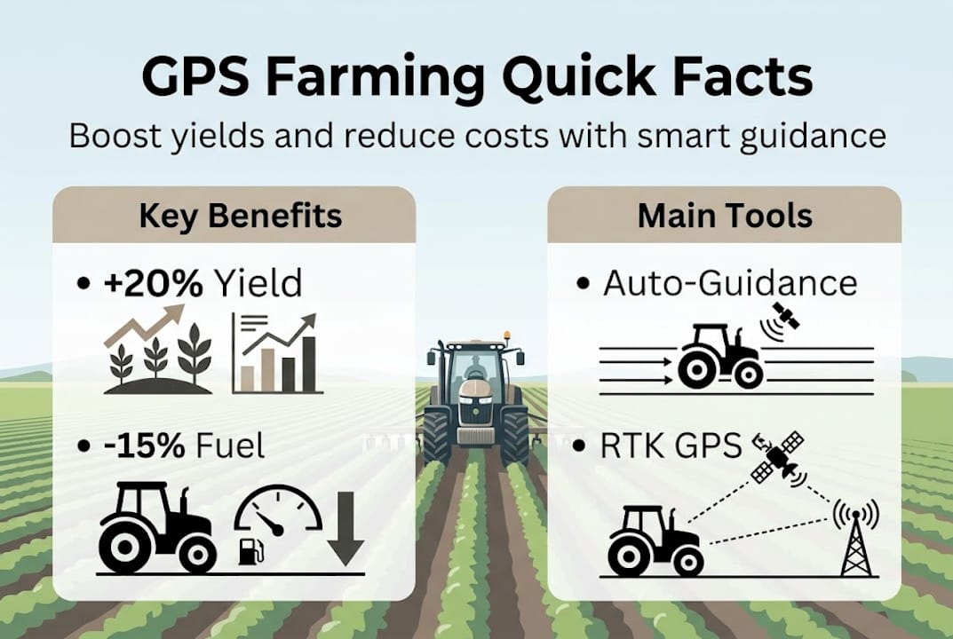
- GPS technology boosts Greek farm yields by 5-20% and reduces inputs effectively.
- High-accuracy GPS units and proper calibration are essential for optimal precision farming results.
- Combining GPS with agroecological practices enhances long-term farm sustainability and productivity.
Most Greek farmers think of GPS as something that lives in a phone or a car dashboard. That assumption is costing them money. GPS systems deliver 5-20% yield increases, 10-15% fuel savings, and 15% fertilizer reductions when applied correctly to agricultural machinery. This article covers everything you need to know about using GPS technology on your farm, from the basics of how it works, to crop management strategies, machinery optimization, and how to handle the limitations that show up in real Greek field conditions.
Table of Contents
- GPS technology basics for agriculture
- How GPS transforms crop management in Greece
- Boosting machinery performance with GPS guidance
- Overcoming GPS limitations and maximizing results
- A fresh perspective: Beyond ROI—tech adoption versus agroecology
- Take the next step: Upgrade your machinery and systems
- Frequently asked questions
Key Takeaways
| Point | Details |
|---|---|
| Increase yields and efficiency | GPS technologies can boost crop yields by up to 20% and cut fuel usage significantly through optimized field operations. |
| Precision matters | Accurate GPS systems support targeted fertilization and reduce resource waste, unlike basic devices like smartphones. |
| Overcome local challenges | Greek farms can solve signal and accuracy issues with sensor fusion and proper machinery upgrades. |
| Choose local expertise | Providers such as TractorGps and expert guides ensure Greek farmers access tailored solutions for maximum benefit. |
GPS technology basics for agriculture
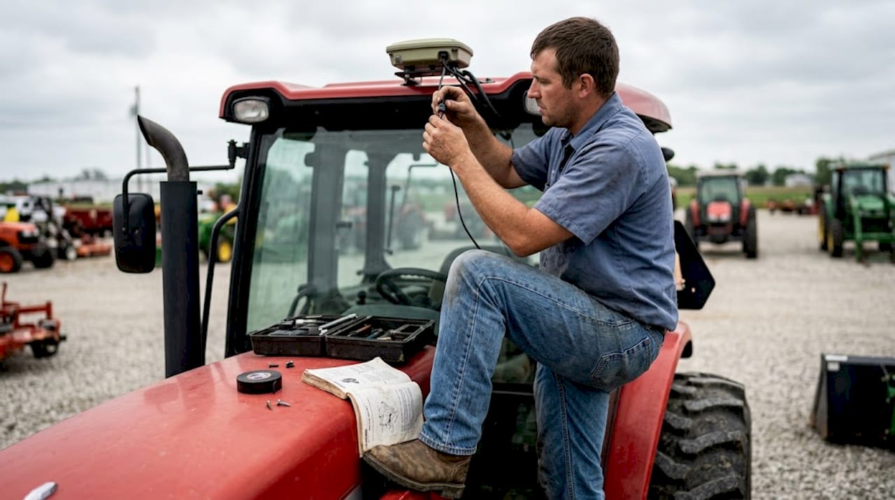
GPS stands for Global Positioning System, a network of satellites that transmit location signals to receivers on the ground. In farming, GPS receivers are mounted on tractors, drones, sprayers, and handheld devices to track position with high accuracy during field operations. But not all GPS is equal, and this distinction matters enormously for precision farming.
Consumer-grade GPS, the kind built into smartphones, is limited to 3-30 ft accuracy with low update rates. That level of precision is fine for finding a restaurant, but it is completely unsuitable for tasks like row guidance, variable rate application (VRA), or field boundary mapping. Agricultural GPS units use correction signals from ground stations or satellites to achieve sub-inch accuracy, which is a completely different category of performance.
Here is a quick look at common GPS-enabled equipment used in farming:
- GPS-guided tractors: Use real-time positioning to follow precise field paths with minimal driver input
- Drones with GPS: Map fields, monitor crop health, and apply inputs in targeted zones
- Handheld GPS devices: Used for soil sampling, boundary marking, and scouting
- GPS sprayers: Apply chemicals only where needed, reducing waste and overlap
The table below shows how different GPS types compare in an agricultural context:
| GPS type | Accuracy | Best use case |
|---|---|---|
| Smartphone GPS | 3-30 ft | Basic navigation only |
| SBAS-corrected GPS | 1-3 ft | Field mapping, basic guidance |
| RTK GPS | Under 1 inch | Auto-steering, precision VRA |
| DGPS | 1-3 ft | Moderate precision tasks |
For a deeper look at how precision tools fit together, the precision farming guide covers the full technology stack. You can also explore how telematics in agriculture connects GPS data to fleet and field management systems.
Pro Tip: Never use a consumer smartphone as your primary GPS tool for field operations. Invest in agriculture-specific units with correction capability. The price difference pays for itself within one or two seasons through reduced input waste and better coverage accuracy.
How GPS transforms crop management in Greece
With GPS know-how established, we move into its practical impact on crop management and resource optimization. Greek farms range from small family plots in the Peloponnese to large cereal operations in Thessaly, and GPS delivers measurable value across all of them.
Here is how a GPS-based crop management process typically works:
- Field mapping: Use GPS to create accurate boundary maps and divide fields into management zones
- Soil sampling: Collect geo-referenced soil samples to understand nutrient variability across the field
- Satellite and GIS data integration: Combine GPS data with satellite imagery and GIS layers to identify problem areas
- Variable rate application (VRA): Apply fertilizer, lime, or pesticides at different rates based on zone-specific needs
- Yield monitoring: Track harvest data by GPS location to evaluate which zones performed best
- Seasonal adjustment: Use the previous season’s data to refine next year’s management plan
This process is not theoretical. Precision agriculture process chains in Greece combine GPS with GIS, soil samples, and satellite data for VRA fertilization across 2,667 hectares, proving the model works at scale in Greek conditions.
Here is how conventional management compares to GPS-guided precision management:
| Factor | Conventional management | GPS precision management |
|---|---|---|
| Fertilizer application | Uniform across field | Zone-specific, reduced waste |
| Fuel use | Higher, unoptimized paths | Reduced with guided passes |
| Yield tracking | Estimated averages | GPS-mapped, zone-level data |
| Input cost | Higher per hectare | Lower with targeted use |
Key stat: GPS systems deliver 5-20% yield increases, 10-15% fuel savings, and 15% fertilizer reductions, making the technology one of the highest-ROI investments available to Greek farmers today.
For practical strategies on boosting yields with GPS, there are field-tested approaches tailored to Greek conditions. You can also explore how crop management sensors work alongside GPS to give you a fuller picture of what is happening in your fields.
Boosting machinery performance with GPS guidance
Efficient crop management sets the stage for GPS-driven machinery optimization, which unlocks further gains. When your tractor follows a GPS-guided path, you eliminate the guesswork and the waste that comes with manual steering.
GPS guidance systems for machinery generally fall into two categories:
- Lightbar systems: A visual display mounted in the cab shows the driver how far off the intended path they are. The driver corrects manually, but with much better precision than unaided steering.
- Automated steering systems: The GPS signal connects directly to the tractor’s steering mechanism. The machine follows the path with no driver input required, freeing the operator to focus on implement monitoring.
- Section control systems: GPS triggers individual boom sections on sprayers or planters to turn on or off automatically, preventing double application in already-covered areas.
- GPS data loggers: Record every field pass for later analysis, helping you identify inefficiencies and plan better routes next season.
Lightbar and automated steering systems reduce overlaps from 5% to under 3%, saving fuel, chemicals, and time across the entire operation. That might sound like a small number, but on a 500-hectare farm, a 2% reduction in overlap translates directly into thousands of euros saved annually.
“GPS auto-guidance is not just about straight lines. It is about repeatable, documented field operations that reduce input costs and operator fatigue across every single pass.”
In Greece, TractorGps provides GPS auto-guidance, weather stations, and precision services covering Greek agricultural markets, showing that local support for these systems is already well established.
For more on how these systems integrate with farm management, the guide on telematics in Greek farming explains the connectivity layer. If you are evaluating specific equipment, the GPS machinery guide covers the key selection criteria.
Overcoming GPS limitations and maximizing results
To fully benefit from GPS, you must understand and overcome typical limitations on Greek farmland. No technology is perfect, and GPS has real weak points that show up in specific field conditions.
The most common challenges include:
- Signal loss under dense tree canopies, such as olive groves or orchards
- Multipath errors caused by buildings, metal grain silos, or hillside terrain reflecting satellite signals
- Accuracy drops during atmospheric interference or when fewer satellites are visible
- Battery and connectivity issues with handheld devices in remote areas
GNSS signal loss under tree canopies and multipath from buildings or metal structures are recognized edge cases that require INS/IMU (Inertial Navigation System/Inertial Measurement Unit) fusion for continuity. IMU uses accelerometers and gyroscopes to estimate position when satellite signals drop, bridging the gap until the signal returns.
Here is a practical checklist for maximizing GPS effectiveness on your farm:
- Mount antennas correctly: Place GPS antennas on the highest point of the machine, away from metal obstructions
- Calibrate regularly: Run calibration routines at the start of each season and after any major equipment change
- Use correction services: Subscribe to SBAS or RTK correction networks for consistent sub-foot accuracy
- Pair with IMU sensors: Add inertial measurement units to maintain guidance during brief signal interruptions
- Plan field routes: Avoid passes that run directly under dense canopy or close to large reflective structures
- Update firmware: Keep your GPS receiver firmware current to benefit from accuracy improvements
Pairing GPS with multi-sensor fusion using IMU and vision systems is the recommended approach for machinery optimization in GNSS-denied areas, according to precision agriculture experts. This is not an exotic solution. It is increasingly standard in modern agricultural GPS units.
Pro Tip: Schedule a calibration check every 30 operating hours. Drift in GPS performance is gradual and easy to miss until accuracy has degraded significantly. A quick calibration keeps your guidance data reliable all season.
The smart farming guide covers how GPS fits into a broader precision technology ecosystem, and the equipment upgrade checklist helps you assess what your current setup needs to support GPS adoption.
A fresh perspective: Beyond ROI—tech adoption versus agroecology
After mastering GPS’s technical side, it is vital to step back and look at the broader context for Greek farms. The conventional wisdom is straightforward: GPS delivers ROI, so adopt it. And that is largely true. Empirical benchmarks show consistent ROI: 15-25% fuel cuts and higher yields are well documented across precision agriculture studies.
But here is the part most technology vendors will not tell you. Intensive farms that adopt GPS without integrating agroecological practices often plateau. They get the fuel savings, but they miss the deeper gains that come from understanding their land’s biological systems. GPS tells you where to apply inputs. It does not tell you whether you should be applying them at all.
The Greek farms that see the best long-term results are the ones that use GPS data to ask better questions, not just to execute the same practices more efficiently. Combine your GPS yield maps with soil biology data. Use the precision agriculture success stories as a benchmark, but do not copy them blindly. Your land has its own character. GPS is a tool, not a strategy.
Take the next step: Upgrade your machinery and systems
If you are ready to take advantage of GPS capabilities, the right machinery parts and maintenance practices are what keep your investment performing at its best. GPS guidance is only as reliable as the equipment it runs on. Worn steering components, outdated hydraulics, or poorly maintained sensors will undermine even the best GPS system.
At pexlivanidis.com, you will find over 20,000 agricultural machinery parts with free shipping across Greece for orders over 100€. Start with a clear understanding of what your tractor needs by reviewing machinery parts explained, then follow the maintenance tips guide to keep your equipment in peak condition. When you are ready to move forward, the upgrade tips for success will help you prioritize the right investments.
Frequently asked questions
How accurate are GPS systems for agricultural machinery?
High-grade agricultural GPS using RTK correction achieves under one inch of accuracy. Smartphone GPS offers only 3-30 ft of precision, which is completely unsuitable for row guidance or variable rate application.
Can GPS help reduce fertilizer and fuel consumption?
Yes. GPS systems deliver 10-15% fuel savings and up to 15% fertilizer reductions by optimizing machinery paths and enabling zone-specific application instead of uniform field treatment.
What GPS challenges do Greek farmers face?
The most common issues are signal loss under olive groves and orchards, and multipath errors near buildings or metal structures. GNSS signal loss requires INS/IMU fusion to maintain guidance continuity during these interruptions.
Are there local GPS providers for agriculture in Greece?
Yes. TractorGps offers GPS auto-guidance and precision farming services specifically designed for Greek agricultural markets, including weather stations and field monitoring tools.